Gather info through records and surface features. Detect existing utilities with non-destructive testing. Confirm depth, material and more with test holes / daylighting.

Do you need to verify pipe pitch and depth or determine utility condition? Complete excavation and receive exact utility location and measurements. We use utility locating and vacuum excavation equipment to determine the location and existence of underground utilities to prevent damages.
Here are the quality levels of subsurface utility engineering data:

QL-D data is the least reliable form of utility data because it is information that is solely based on existing utility records, oral records, and memory of work performed at a site. QL-D data should never be considered reliable enough for critical tie-ins or utility crossings. The existing utility information from this level may be incomplete or incorrect.
CI/ASCE 38-02 outlines four different quality levels for the depiction of subsurface utility data. Each quality level represents a different “reliability” for the utility information presented.

Quality Level C data is slightly more reliable than Quality Level D because it involves surveying the area and using professional judgment in correlating above-ground utility features with QL-D data.
Visible above-ground utility features can be found during a field employee walkthrough, including:

Quality Level B is obtained in the field using surface geophysical equipment to designate the underground utility within an acceptable tolerance zone.
The utilities are designated using paint and flags, which can be surveyed and plotted on project drawings. QL-B data is the most widely used quality level for subsurface utility engineering.
This involving detecting existing utilities horizontally and can give an approximate depth depending on soil conditions.

Quality Level A data is the most reliable form of utility data because it involves physically exposing and confirming the existence of underground utilities using vacuum excavation. A small 12-18″ diameter hole is excavated over the utility. Utility data collected includes:
QL-A data is most commonly acquired at critical conflict points for proposed installations of structures or utility systems. Vacuum excavation confirms utilities by exposing them compared to detecting utilities (QL-B).
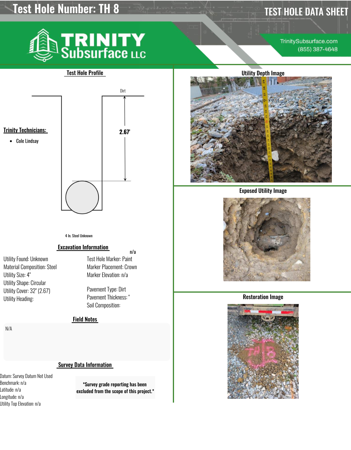
With a test hole report, underground features are observed and documented with precision. Trinity Subsurface can send you our test hole report deliverable as an example of our quality-focused work.
Preliminary step: designate utilities before digging a test hole.
Learn More >Next step: assess pipe condition from the interior perspective and determine pitch.
Learn More >Next step: build an AutoCAD map from potholing insights.
Learn More >ASCE/UESI/CI 38-22, the current standard guideline for investigating and documenting existing utilities, outlines four different quality levels for the depiction of subsurface utility data. Each quality level represents a different “reliability” for the utility information presented.
This standard is used by engineers, contractors, project managers and more.
The levels range from Quality Level D (least reliable) through Quality Level A (most reliable).
Quality Level D data is the least reliable form of utility data because it is information that is solely based on utility records and oral recollections. QL-D data should never be considered reliable enough for critical tie-ins or utility crossings.
Quality Level C data is slightly more reliable because it involves surveying and using professional judgment in correlating above-ground utility features with QL-D data.
Quality Level B data is significantly more reliable than QL-C data because it is obtained in the field using surface geophysical equipment to designate the underground utility within an acceptable tolerance zone. The utilities are designated using paint and flags, which can be surveyed and plotted on project drawings. QL-B data is the most widely used quality level used when subsurface utility engineering is utilized.
Quality Level A data is the most reliable form of utility data because it involves physically exposing an underground utility using vacuum excavation. Once exposed, critical utility data can be collected including precise horizontal location and exact utility elevation. QL-A data is most commonly acquired at critical conflict points for proposed installations of structures or utility systems.
During a Quality Level B utility data investigation, several steps are taken to collect as much utility data as possible. Utility records are researched by all utility companies and property owners in the vicinity of the project.
The project site is then scanned using our surface geophysical equipment, and existing underground utilities are designated on the surface using paint and flags.
Using survey equipment, the locations of the designated utilities are shot in using your established project control, or we can set new control if needed. Utility data can be delivered in a variety of formats including CAD, GIS, Matterport scans and MicroStation. Utility data is presented as a stand-alone file that can be easily referenced into your existing civil drawings.
Vacuum excavation can be used to confirm detected utilities by exposing them safely using air or water. This service goes by many names, including test holing, daylighting, and soft digging.
By exposing utilities, you can determine and document depth, pitch, size, material, and other conditions.
This information can generate a Quality Level A test hole report for the most accurate utility information possible.
Subsurface utility engineering is used to prevent costly unforeseen conflicts that are commonly discovered during the construction phase of a design project.
SUE can help reduce risk to workers as well as reduce costs associated with unknown conflicts, such as re-engineering, utility conflict resolution, and utility relocation.


