Locate private underground utilities, foreign objects, and anomalies.


A private utility is an utility that is not owned by a utility company. While public utilities up to the meter can be marked via 811 or Miss Utility, you are responsible for maintaining and locating private lines. Trinity Subsurface can locate all private utilities on-site.
Anyone breaking ground is required by law to notify Call 811 in advance of excavation. Only 68% of the underground utilities are owned by a public utility company, leaving the remaining 32% to private utility owners who may not know about 811 or Miss Utility.
The percentage of unmarked utilities dramatically increases when working on private property or private campuses including:
- Hospitals
- Universities
- Industrial Facilities
- Airports
- Military Sites
Electromagnetic equipment is effective at locating metallic utilities such as metallic water pipes, electric cables, telephone cables, and metallic gas pipes to a depth of up to 15 feet. Using a traceable duct rod and sonde field employees can locate storm and sewer lines with breaks and blockages as well as pinpoint empty conduits. We can also use full polarization ground penetrating radar and ultra-wideband electromagnetic induction to locate unexploded ordnances.
We will also use a split box or Aquatronics tracer to confirm utilities, metal tanks, manhole lids, and reinforced slabs. Ground penetrating radar is used to aid in the confirmation of electromagnetic targets, and to designate the location of utilities and structures that were not detected using electromagnetic techniques.
The depth at which a utility can be detected is dependent on a combination of the size and material composition of the utility, the depth of the utility, the conductivity of the utility, and the material composition of the back-fill and earth materials surrounding the utility.
Trinity Subsurface, LLC field employees has a range of geophysical equipment utilized for private utility location. If the project scope extends past the limitations of typical locating, our team has access to additional technologies to resolve any mapping issues, including vacuum excavation.
Striking underground utilities can lead to property & environmental damages, project delays, service outages excessive costs, unexpected fines, serious injuries, and even death in the worst case scenarios. Locating utilities is crucial to protect you and your site.
The Common Ground Alliance (CGA) estimates that there are $83.2 billion dollars in economic damages each year from damaged utilities.
In addition to a superior utility mark out using paint and flags, we provide our clients with the documentation needed to proceed with construction.
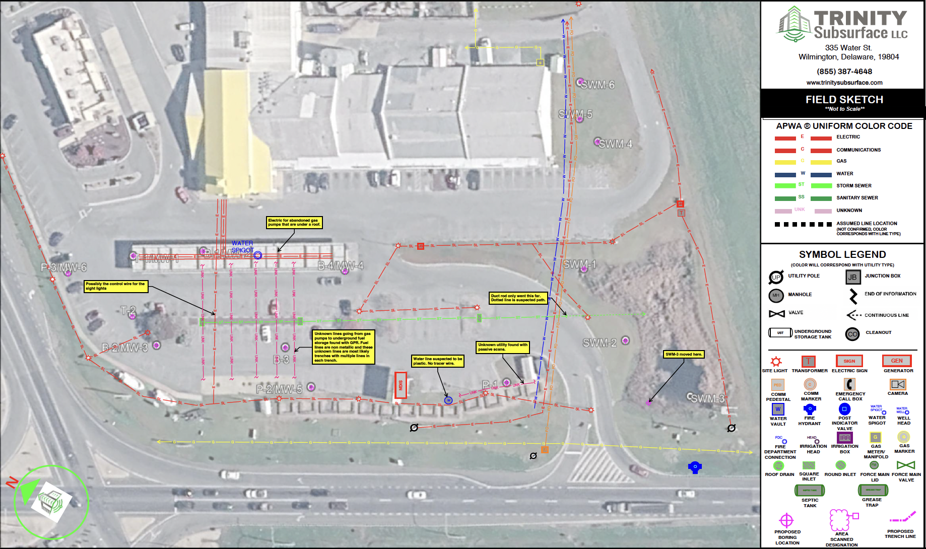
Trinity Subsurface generates a field report, documenting survey dates, utilities designated, equipment utilized, site contacts made, and any limitations or unusual field conditions encountered while performing the work. Our field employees also draft a field sketch, depicting the underground utilities found or verified.
The field sketch will be formatted on our 11″x17″ sketch template using a Google satellite image of the work area. Need a construction drawing updated? A field sketch can overlay any client-provided PDF document.
If you need additional deliverables for your project, Trinity Subsurface can provide CAD/GIS mapping.
Trinity Subsurface prices field work by the half day or full day for a single technician, or by the job on larger scopes. Typical rates for one technician performing electromagnetic and GPR locating run $900 to $1,400 for a half day and $1,850 to $2,200 for a full day. The lower end of each range covers a targeted locate: a defined work area with specific utilities to find, such as clearing a bore path, marking a known service before a tie-in, or checking a single trench line. The upper end covers a comprehensive sweep of the work area, grid scanning with both electromagnetic equipment and ground penetrating radar to designate unrecorded and abandoned lines alongside the known ones.
Vacuum excavation test holes, CAD and GIS mapping, traffic control, prevailing-wage projects and travel outside the local service area are priced separately. Every project receives a written proposal listing field days, deliverables, assumptions and limitations before work begins.
Yes, under the right conditions. Electromagnetic locating cannot trace PVC, HDPE or other non-metallic pipe on its own, because there is no conductor to energize. That is why a plastic water service or a PVC storm line often goes unmarked. Ground penetrating radar detects the pipe itself rather than a signal carried on it, so it can find non-metallic lines.
Detection depends on depth, pipe diameter, whether the line is full or empty, and how much contrast there is between the pipe and the surrounding soil. Dense clay, saturated ground and deep fill all reduce what GPR can resolve. See Utility Locating Limitations for what these methods can and cannot detect.
Trinity Subsurface does. 811 and Miss Utility mark public utility-owned lines up to the meter or point of service. Everything past that point is private, owned by the property owner, and outside the 811 ticket: site lighting, feeds to outbuildings, generator and transformer runs, and the distribution across private campuses such as hospitals, universities and industrial facilities.
Those lines carry the same strike risk as public ones, and they are marked only if a private locator is engaged.
A locate does not require existing drawings. Trinity Subsurface designates what is actually in the ground using electromagnetic equipment and ground penetrating radar, marks it in the field with paint and flags, and documents it on an 11x17 field sketch drawn over an aerial image of the work area.
Trinity can research utility owner records in the project vicinity before mobilizing. For design work, the designated lines can be surveyed to project control and delivered in CAD, GIS or KMZ format.
Most requests are on site within three business days. Where scheduling is needed immediately, Trinity can often mobilize within one, and same-day response is possible in some cases depending on crew location and the current schedule. If the work is urgent, let our team know when you call or submit a proposal online and the scheduling team will tell you what is actually possible that day.
Subsurface Utility Engineering Quality Level B designating across the new arena site ahead of construction, plus a ground penetrating radar and split-box search for pile caps left from the previous structure in Lot G.
Utility locating and test holes on Merck's West Point campus, including work for the B50 utility rack and B54 chiller expansion, and test holes at Building 41 that exposed a 12-inch ductile iron water main at five feet.
Repeat mark-outs and storm test holes ahead of excavation for the site's general contractor.
Rated 4.9 out of 5 from 223 Google Reviews.
“Prompt scheduling and reliable service. Reports go out quickly. Private locating is very important, do not overlook the service and added value that is provided with this company.”
Duane W., Google review
“Fast response and excellent quality locating services by a qualified and helpful technician! Also fast and accurate follow up documentation of findings. 10 out of 10 experience with Trinity.”
Rodney H., Google review
“Trinity Subsurface has been spot on every time they are on site. They are punctual and always keep us informed when on site.”
John O., Google review
“They were thorough, professional, and they really worked hard. They made sure I completely understood what was done.”
Adam D., Google review
“The crew did a perfect job. Exactly what I needed, right on time, very friendly and courteous. Very happy!!”
Chuck B., Google review
Local crews, local contacts and nearby project history for the areas we work in most:
How we use radar on a locate: Ground Penetrating Radar (GPR) Services.
Do you need to update blueprints for new building construction or utility installation? Locate lines before you design!
Protecting utilities starts with site investigations and specialty equipment. Here are the tools used to locate underground utilities:

Electromagnetic equipment is effective at locating metallic utilities up to 15 feet below the surface including:
The EM equipment consists of a transmitter and receiver. The transmitter applies a signal, set to a specific frequency, to a metallic line for the receiver to pick up.

The duct rodder has a tracing cable embedded within the fiberglass rod for quick utility locating without digging or trenching. The copper wire is energized with an electromagnetic signal.
When the energized duct rodder is pushed into the underground pipe, the signal radiates outward through the soil to the surface. A signal receiver detects the frequency applied, allowing the entire buried utility pipe to be traced and marked.

All project sites are scanned with an Aquatronics A6 Split-Box locating device. This device emits an electromagnetic frequency to locate:
The Split-Box is a hand-held instrument, consisting of a transmitter and a receiver. The instrument traces underground conductive networks. The split box is crucial to detect underground structures when no surface features are present.

Ground penetrating radar aids in the confirmation of metallic targets and is capable of detecting non-metallic lines such as:
The GPR cart sends continuous electromagnetic pulses through the earth, then receives the reflected waves back from the subsurface structures. The results construct an image of the subsurface structures which is marked out by the field employee.

Next Step: determine the exact depth and confirm detected utilities with vacuum excavation.
 Learn More >
Next Step: conduct a thorough cleanout of found utility lines.
 Learn More >
Next step: map untraceable sewer or storm laterals.
 Learn More >
Next step: discover a leak source found on a utility locate.
 Learn More >
Next step: complete survey-grade mapping of utility mark outs.
 Learn More >
The number one risk to construction workers is caused by excavating and drilling around underground utilities and unexploded ordnances.
Breaking ground blind will lead to costly utility repairs and possible state fines. Locate all utilities within the project scope to avoid accidental strikes. Keep your construction project on time and on budget by preventing site damage.
Utility location is a great preventative measure to avoid strikes during excavation. Trinity promises speedy service response, catered to your project timeline.

Pinpoint buried utilities with a 24-hour field sketch turn-a-round. Submit your contact info to see how user-friendly our deliverables are for project managers, foremen, and engineers alike. Trinity Subsurface can provide utility mapping in a PDF, CAD, or GIS format.